Key facts
- A quantum gravity gradient sensor uses clouds of ultra-cold atoms as test masses, so it needs no moving mirrors or springs that drift.
- In a 2022 Nature paper, a Birmingham-led team measured with a statistical uncertainty of 20 eotvos and located a buried 2 m tunnel from a survey along an 8.5 m line.
- The key advance was suppressing vibration noise, so that better instruments translate directly into shorter measurement times.
- The same physics supports inertial navigation that does not depend on satellite signals; early field tests include a 2011 airborne measurement and a 2024 test on London's District line.

Quantum cartography is the use of quantum sensors, above all atom interferometers, to measure small variations in gravity and so to map what lies beneath the surface or to fix a position without satellites. The best-documented demonstration is a 2022 paper in Nature in which a quantum gravity gradient sensor located a buried tunnel in a field survey. The same family of instruments is also being tested as an inertial navigation aid for ships, aircraft and trains. This note explains how the sensors work, what the 2022 result showed and where navigation tests stand. It belongs to the science notes on quantum technology.
What an atom interferometer measures
An atom interferometer applies the logic of an optical interferometer to matter. English Wikipedia notes that the first modern atom interferometers were demonstrated in 1991. In the widely used Kasevich-Chu design, a cloud of cold atoms receives three laser pulses of the Raman type, a pi/2 pulse, a pi pulse and a second pi/2 pulse. The first splits each atom into a superposition of two paths, the second redirects them and the third recombines them.
If the atoms are accelerating, for example because they are in free fall under gravity, the two paths pick up a phase difference. For the standard sequence that phase is given as k_eff times g times T squared, where k_eff is the effective wave vector of the laser light, g the acceleration and T the time between pulses. Because of the T squared term, sensitivity grows rapidly with free-fall time, which is why laboratory instruments often use tall vacuum tubes. Wikipedia lists accelerometers, gyroscopes and gradiometers among the applications.
Atoms are a good reference for a simple reason: every atom of a given isotope is identical. A mechanical spring or mirror ages, drifts and changes with temperature, while the cold atoms are a fresh, uniform test mass every time the cloud is prepared.
From gravity to gradient
Gravity changes from place to place because mass is distributed unevenly. A void such as a tunnel removes mass and slightly lowers the pull above it. Geophysicists often measure not the pull itself but its gradient, the change of gravity over a short distance. Wikipedia defines the unit of gradient, the eotvos (E), as 10 to the power minus 9 per second squared, and gives scale: a person at 2 m produces about 1 E, while mountains produce several hundred E.
A gradiometer typically differences two accelerometers. Any motion common to both, such as a vibrating platform, cancels, and only the difference remains. Wikipedia reports that more than 2.5 million line kilometers have been surveyed this way for oil and minerals, and that the Lockheed full-tensor instrument came from a US Navy Trident program and became publicly known through the film The Hunt for Red October in 1990.
The 2022 field result
Stray and colleagues, a University of Birmingham-led team with industry and defense-laboratory partners, reported in Nature 602 (23 February 2022) a quantum gravity gradient sensor that worked outside the laboratory. Their instrument suppressed several noise sources at once: micro-seismic vibration, laser noise, thermal drift, magnetic fields and tilt.
| Quantity | Reported value |
|---|---|
| Statistical uncertainty of the gradient | 20 E |
| Survey geometry | 0.5 m resolution along an 8.5 m line |
| Target | a tunnel about 2 m across |
| Signal-to-noise ratio | 8 |
| Inferred horizontal centre | within 0.19 m |
| Inferred depth | 1.89 m, with an uncertainty range of -0.59 m to +2.3 m |
The depth estimate came from Bayesian inference over the survey data. The authors list aquifers and the water table, archaeology, soil properties and water content, and construction risk for infrastructure among the uses of such maps.
The most important point in the paper is about the noise. Because the vibration noise was removed rather than averaged away, any later improvement of the instrument turns directly into a shorter measurement time. That is the practical meaning of “cartography”: a sensor that can be carried to a site and used there, rather than operated in a vibration-isolated laboratory.
From maps to navigation
A map of gravity is also a map for finding oneself. If a vehicle carries a sensitive gravity or acceleration sensor and a stored gravity map, it can match its readings against the map. More directly, an atom-interferometer inertial measurement unit tracks acceleration and rotation, so that a vehicle can integrate its own motion without outside signals.
According to English Wikipedia’s article on quantum navigation:
- Such units are aimed at settings where GPS is unavailable or unreliable, submarines being the usual example.
- The first airborne acceleration measurement with an atom interferometer was made on an Airbus A300 in 2011.
- Imperial College London tested an experimental quantum compass on London’s District line in 2024.
- Sandia announced a silicon photonic chip for sensing in 2024.
- DARPA and the UK Ministry of Defence are pushing prototypes.
These are prototypes and trials, not products in routine service. Wikipedia’s article on quantum sensors adds that the United States judges quantum sensing to be the most mature quantum technology for military use.
Other quantum sensors
Atom interferometers are one of several sensor families that can be grouped under the heading of quantum sensing. Wikipedia’s article gives four criteria for solid-state quantum sensors: discrete energy levels, the ability to initialize and read out the state, coherent manipulation, and interaction with the quantity being measured. Examples relevant to mapping include:
- Vapor-cell magnetometers. Wikipedia gives about 300 fT per root hertz for caesium vapor, and notes micro-fabricated optically pumped magnetometers used to detect brain seizures.
- SQUIDs, superconducting magnetometers, also described in the same article.
- Nitrogen-vacancy centers in diamond. A defect with spin-dependent photoluminescence and millisecond coherence at room temperature, used as a sensor.
- Squeezed light. The LIGO gravitational-wave detectors use it to reduce measurement noise.
Quantum sensors are a different branch of quantum technology from quantum computers. Computers have to fight decoherence over long calculations, whereas a sensor wants to be disturbed by exactly the quantity it measures. For the computing side, see has quantum advantage been achieved? and its second part on the evidence. The history of precise measurement has a long thread, from the instruments of seventeenth-century Florence described in the physicists of Florence to the laser-cooled atoms of today.
What remains open
The 2022 survey was short and the target was a deliberately simple tunnel. Turning the result into routine mapping requires smaller, cheaper and more rugged instruments, and the paper itself points to improved instruments as the route to faster surveys. For navigation, the open questions are how long a unit can run without drift and how it copes with the motion of a real vehicle. This page reports only what the cited sources state, and where they give no number it gives none.
About the image
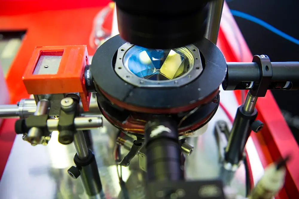
The image shows a commercial atom interferometer on display at the European Space Agency’s first quantum technology workshop. Its description states that the instrument uses clouds of ultra-cold atoms to make extremely precise measurements of variations in local gravity, the principle behind the survey described above.
Frequently asked questions
What is quantum cartography?
It is the use of quantum sensors, mainly atom interferometers, to map tiny variations in gravity or other fields so that hidden structures can be located. The term is also used for navigation, where the same sensors track position without satellite signals.
How does an atom interferometer measure gravity?
A cloud of cold atoms is split by laser pulses into two paths, left to fall, and recombined. Gravity changes the phase difference between the paths, and the standard pulse sequence gives a phase of k_eff times g times T squared, where T is the time between pulses.
What is an eotvos?
The eotvos (symbol E) is the unit of gravity gradient, equal to one billionth of a second to the power minus two. A person standing 2 m away produces about 1 E, while mountains produce several hundred E.
Can quantum sensors replace GPS?
Not yet. Atom-interferometer inertial units are being developed for places where satellite signals are unavailable, such as submarines, and prototypes have flown and ridden trains, but they remain experimental.
Sources and open data
- Quantum sensing for gravity cartography, Nature
- Atom interferometer, English Wikipedia
- Gravity gradiometry, English Wikipedia
- Quantum navigation, English Wikipedia
- Quantum sensor, English Wikipedia